


Old Citronelle Senior Center, Mobile County, Alabama
About
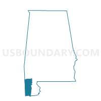
Outline

Summary
| Unique Area Identifier | 522559 |
| Name | Old Citronelle Senior Center |
| County | Mobile County |
| State | Alabama |
| Area (square miles) | 89.80 |
| Land Area (square miles) | 89.06 |
| Water Area (square miles) | 0.74 |
| % of Land Area | 99.18 |
| % of Water Area | 0.82 |
| Latitude of the Internal Point | 31.09015490 |
| Longtitude of the Internal Point | -88.28309740 |
Maps


Graphs
Select a template below for downloading or customizing gragh for Old Citronelle Senior Center, Mobile County, Alabama


Neighbors
Neighoring Voting District (by Name) Neighboring Voting District on the Map
- Chunchula Baptist Church, Mobile County, AL
- Deer Park/Epworth Fire House, Washington County, AL
- Dees Comm/SimsChapel/Charity Chapel Voting District, Washington County, AL
- Fellowship Baptist Church, Mobile County, AL
- Leakesville Voting District, Greene County, MS
- Maples Voting District, Greene County, MS
- Mt. Vernon Civic Center, Mobile County, AL
- Turnerville Community, Mobile County, AL
Top 10 Neighboring County Subdivision (by Population) Neighboring County Subdivision on the Map
- Citronelle CCD, Mobile County, AL (9,534)
- District 1, Greene County, MS (5,305)
- Mount Vernon CCD, Mobile County, AL (4,942)
- McIntosh CCD, Washington County, AL (4,589)
- Fruitdale CCD, Washington County, AL (2,543)
- District 4, Greene County, MS (2,431)
Top 10 Neighboring Place (by Population) Neighboring Place on the Map
Top 10 Neighboring Unified School District (by Population) Neighboring Unified School District on the Map
- Mobile County School District, AL (399,587)
- Washington County School District, AL (17,581)
- Greene County School District, MS (14,400)
Top 10 Neighboring State Legislative District Lower Chamber (by Population) Neighboring State Legislative District Lower Chamber on the Map
- State House District 102, AL (50,860)
- State House District 65, AL (38,681)
- State House District 105, MS (24,574)
Top 10 Neighboring State Legislative District Upper Chamber (by Population) Neighboring State Legislative District Upper Chamber on the Map
- State Senate District 34, AL (155,435)
- State Senate District 22, AL (137,373)
- State Senate District 43, MS (62,195)
Top 10 Neighboring 111th Congressional District (by Population) Neighboring 111th Congressional District on the Map
Top 10 Neighboring Census Tract (by Population) Neighboring Census Tract on the Map
- Census Tract 9502, Greene County, MS (6,308)
- Census Tract 60, Mobile County, AL (4,996)
- Census Tract 58, Mobile County, AL (4,942)
- Census Tract 442, Washington County, AL (4,589)
- Census Tract 59, Mobile County, AL (4,538)
- Census Tract 443, Washington County, AL (2,543)